


Marizy

Marfee
User
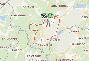

Length
13.9 km

Max alt
395 m

Uphill gradient
224 m
Km-Effort
16.9 km

Min alt
319 m

Downhill gradient
222 m
Boucle
Yes
Creation date :
2023-02-24 17:19:30.469
Updated on :
2023-02-24 17:19:45.955
3h49
Difficulty : Difficult

FREE GPS app for hiking
 SityTrail
IGN / Geographical institutes
SityTrail Plus
The world is yours!
About
Trail Walking of 13.9 km to be discovered at Bourgogne-Franche-Comté, Saône-et-Loire, Le Rousset-Marizy. This trail is proposed by Marfee.
Positioning
Country:
France
Region :
Bourgogne-Franche-Comté
Department/Province :
Saône-et-Loire
Municipality :
Le Rousset-Marizy
Location:
Unknown
Start:(Dec)
Start:(UTM)
607933 ; 5157960 (31T) N.
Comments